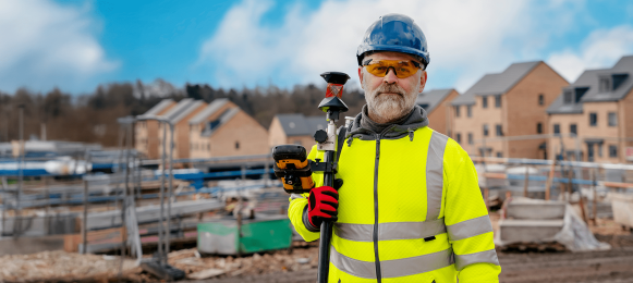
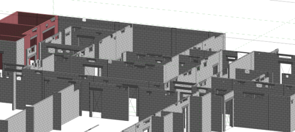
Laser scanning technology, a sophisticated method of surveying that captures vast amounts of precise spatial data with unprecedented speed, is helping to transform construction. For decades, traditional surveying relied on laborious manual measurements, often prone to human error and limited in scope. Today, laser scanning offers a digital alternative, generating highly detailed three-dimensional models that provide an unparalleled understanding of physical environments – a process that represents a fundamental change in how spatial information is acquired, processed and utilised across an entire project lifecycle.
At its core, laser scanning involves devices that emit rapid pulses of laser light. When these pulses strike an object or surface, they reflect back to the scanner, which precisely measures the time taken for each pulse to return. Knowing the speed of light, the scanner can then calculate the exact distance to that point. This process is repeated millions of times per second, with each measured point recorded in three-dimensional space, creating what is known as a "point cloud." A single scan can generate hundreds of millions of data points, collectively forming a dense, accurate digital representation of the real world.
These raw point clouds are then processed using specialised software. This involves filtering out noise, aligning multiple scans captured from different positions to create a unified model and often colouring the points based on photographic imagery captured simultaneously by the scanner. The resulting digital model is a highly precise and comprehensive record of the surveyed environment, far surpassing the detail achievable through conventional methods. This digital twin can then be exported into various formats compatible with Building Information Modelling (BIM) software, CAD programmes and other design and analysis platforms, making it an invaluable asset for various applications.
Speed, accuracy and safety
Laser scanning fundamentally improves the efficiency and reliability of data capture. Traditional surveying techniques, reliant on total stations or GPS, acquire data point by point, a time-consuming process, especially for complex or large areas. Laser scanners, conversely, capture millions of points in minutes or hours, dramatically reducing fieldwork time. This speed is particularly beneficial for large-scale infrastructure projects, complex industrial sites, or urban environments where time is often a critical constraint.
The process also offers an unparalleled level of accuracy. The density of the point cloud means that every surface, every angle and every deviation is captured with minute precision, far exceeding what manual measurements can achieve. This high fidelity is crucial for tasks demanding extreme accuracy, such as façade inspections, volumetric calculations, or detailed topographic surveys of challenging terrain. The reduction in human error, inherent in automated data capture, further enhances the reliability of the resulting datasets.
Furthermore, laser scanning significantly enhances safety. Surveyors can capture data from a safe distance, eliminating the need to physically access hazardous areas like unstable structures, active construction zones, or busy roads. This remote data acquisition minimises exposure to risks, protecting personnel while maintaining data integrity. The ability to capture comprehensive information from fewer vantage points also reduces the overall time spent on site, further mitigating potential hazards. This combination of speed, accuracy, and safety makes laser scanning the preferred choice for demanding surveying tasks.
The impact of laser scanning extends deep into the construction lifecycle, revolutionising processes from initial design validation to quality control and facility management. One of the most powerful applications in construction is the ability to compare design models (e.g., BIM models) against existing site conditions. Laser scans of an existing building, a construction site, or newly installed elements can be overlaid with planned designs. This allows for immediate identification of discrepancies, errors, or potential clashes before they become costly problems on site. For example, a scanned point cloud of recently poured concrete can be compared against the structural design to verify dimensions and plumbness, preventing rework. This proactive approach saves significant time and material waste.
Progress monitoring and quality control
Throughout the construction phase, laser scanning provides an objective, verifiable method for tracking progress and ensuring quality. Regular scans of a site can be compared over time to monitor the installation of components, track deviations from the schedule and verify that work is proceeding according to design specifications. This provides project managers with real-time, quantitative data on construction progress, enabling faster decision-making and more effective problem resolution. Quality control inspections, once reliant on tape measures and visual checks, become a highly precise digital comparison against a 3D model, ensuring strict adherence to tolerances and standards.
Upon project completion, laser scanning is also invaluable for creating highly accurate "as-built" documentation. While design models represent what should be built, as-built models capture what was actually built, including any on-site modifications or unforeseen changes. This comprehensive digital record is critical for future maintenance, renovations, or extensions of the structure. Facility managers can use these precise models to locate hidden pipes, wiring, or structural elements, streamlining maintenance operations and reducing potential damage during future work. The digital as-built becomes a powerful digital twin for the entire lifecycle of the asset.
For large-scale civil engineering projects, laser scanning provides rapid and accurate volumetric calculations. By scanning stockpiles of materials, excavations, or cut-and-fill areas, contractors can precisely determine quantities of earth or aggregate moved. This not only improves cost control and billing accuracy but also enhances efficiency in managing earthworks operations. The ability to quickly and repeatedly capture these volumes ensures that project managers have up-to-date information for material procurement and resource allocation.
Prefabrication and off-site construction:
Laser scanning also plays a crucial role in supporting the growing trend of prefabrication and off-site modular construction. By precisely scanning existing structures or site conditions, highly accurate measurements can be provided to off-site manufacturing facilities. This ensures that prefabricated components are built to exact specifications, guaranteeing a perfect fit when they arrive on site. This precision reduces on-site modifications, minimises waste, and accelerates assembly times, driving efficiency in modern construction methodologies.
All this means that the integration of laser scan data with advanced analytics, artificial intelligence and virtual or augmented reality platforms is opening new frontiers. AI algorithms can be trained to automatically identify specific elements within point clouds, classify objects, or even detect anomalies, further automating the analysis process. Augmented reality overlays can project design models onto the physical site in real-time, providing field personnel with immediate visual guidance and verification.
Mobile laser scanning systems, mounted on vehicles or carried by personnel, allow for rapid data capture over vast areas or within complex interior spaces. The advent of handheld and drone-mounted laser scanners further democratises the technology, making it accessible for a wider range of applications and project scales. This continuous innovation ensures that laser scanning will remain a pivotal technology in the drive towards a more efficient, accurate and digitally integrated construction industry. It is no longer just a specialised tool - it is becoming an indispensable component of the modern builder's toolkit.


